Pinal County, Arizona
Sell your land in Gold Canyon for cash
Parcel Buyers buys vacant-coded lots for cash in the Gold Canyon ZIP area, including lots where water, sewer, or road access still needs parcel-level confirmation. We review the parcel, access, zoning, and utility context, then send a written, no-obligation cash offer within 24 hours. Closing uses an independent, licensed title company, typically in about 10 days, with no fees or commissions.
By Parcel Buyers · · Lot figures from the 2027 Arizona parcel and assessment data · How we made this page
Quick answers
- Who buys land for cash in Gold Canyon?
- Parcel Buyers is a direct land buyer that makes written, no-obligation cash offers on vacant lots and acreage in Gold Canyon, Pinal County, usually within 24 hours. Sales close through an independent title company, typically in about 10 days, with no fees or commissions to the seller.
- What did vacant lots in Gold Canyon sell for in 2025?
- In 2025, vacant lots in Gold Canyon sold for a median of $95,000 across 14 arm's-length sales; the middle half sold for $69,500 to $158,200.
- How many vacant lots are in Gold Canyon?
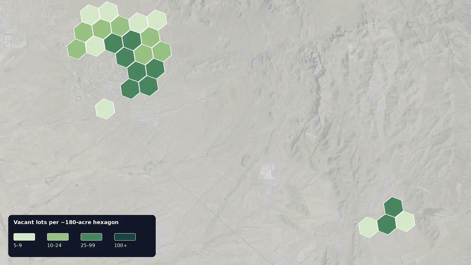
- The 2027 Arizona parcel and assessment data lists 639 vacant residential lots in Gold Canyon; 18% are half-acre lots, and the median lot is 0.53 acre.
- How is a cash offer for land in Gold Canyon set?
- We start from recent sales of similar lots nearby, like the 2025 prices on this page, then adjust for water and sewer, road access, flood zone, lot size and any title issues, and for the time and cost of reselling. You get one written number, not a range.
- How do I know a land buyer in Gold Canyon is legitimate?
- A real buyer closes through an independent, licensed title company and never asks you to pay anything up front. We never charge sellers a fee, deposit or closing-cost advance, and the title company pays you by check or wire at closing.
Local data
Gold Canyon land at a glance
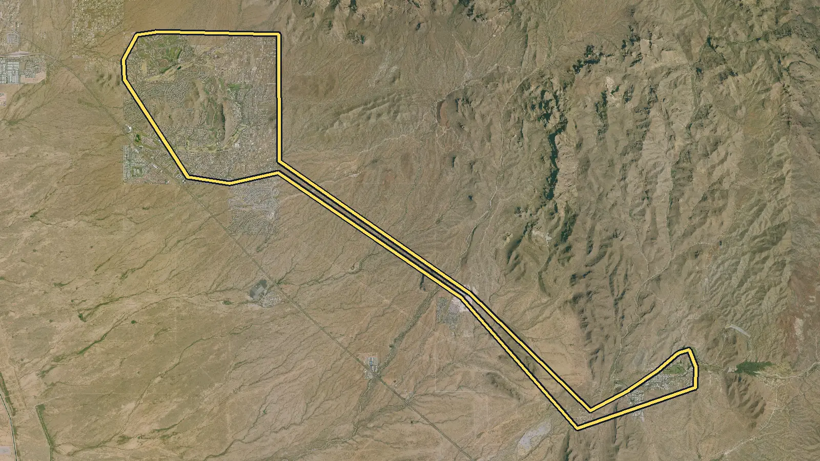
Tax-roll figures cover vacant lots on the Pinal County Assessor's parcel map service whose parcel coordinate falls inside the ZIP 85118 area (Census ZIP Code Tabulation Area 85118); owners with a mailing address in that ZIP give Gold Canyon (with some Queen Valley) as their city; this is a ZIP area, not a city boundary; only the Pinal County part of this ZIP area is counted; lots with no coordinate are in no place in Pinal County. Local rules and services are sourced below.
| Vacant residential lots | 639 parcels classified vacant residential on the 2027 Arizona parcel and assessment data [1] |
|---|---|
| Most common lot size | Half-acre lot (19,000–24,000 sq ft): 18% of vacant lots; next, oversized half-acre at 13%. Median lot: 0.53 acre (23,240 sq ft). [1] |
| Typical county full cash value | $114,000 median county full cash value for a vacant lot; the middle half fall between $67,500 and $173,700 [1] |
| Recent lot sale prices | $95,000 median across 14 arm's-length sales of vacant lots in Gold Canyon (Jan 2025–Dec 2025); the middle half sold for $69,500–$158,200 [1] |
| Owners who live elsewhere | 39% of vacant lots have an owner mailing address outside Arizona (most often WA, NY, HI); 1% outside the U.S. [1] |
| Gold Canyon circulation study | Pinal County marks the Gold Canyon Circulation Study completed. Its scope included road-network changes, regional road alignments, trail connections, and priority transportation improvements. [5],[6] |
| Setbacks and storage sheds | County setback requirements vary with a lot's zoning district. Pinal County also regulates where storage sheds may sit and requires permits for some sheds. [4] |
| Road acceptance standards | Before considering an unmaintained road for its maintenance system, Pinal County requires engineering, right-of-way, drainage measures, and paving. Meeting those requirements does not guarantee acceptance. [7] |
| Septic application costs | For a proposed septic system under 2,999 gallons per day, Pinal County lists a $296 permit fee. Its fee schedule separately lists $94 for a site investigation or evaluation. [8] |
| Unincorporated jurisdiction | Pinal County ordinances identify Gold Canyon as unincorporated, so county planning and zoning records are central to parcel review. [3],[4] |
| Flood review | The county regulates FEMA floodplains, certain watercourses, erosion-hazard areas, and local floodplains that may not be shown on FEMA maps. [9] |
| Sewer utility context | The Arizona Corporation Commission lists annual reports for Liberty Utilities' Gold Canyon sewer company, but parcel service and connection terms still require direct confirmation. [11] |
| Superstition Wilderness | Apache Junction's regional map places Gold Canyon beside the Superstition Wilderness. The Forest Service says the wilderness covers 160,115 acres and manages motorized and mechanized intrusions near its boundaries. [14],[15] |
Data: Mohave County Assessor's Office, Pinal County Assessor's Office, Cochise County Assessor, Santa Cruz County Assessor, Pima County Assessor, Graham County Assessor and La Paz County Assessor. Counts, medians and shares only; no owner names, parcel numbers, addresses or row-level data are published.
Pricing
What is a lot in Gold Canyon worth?
In 2025, vacant lots in Gold Canyon sold for a median of $95,000 across 14 arm's-length sales; the middle half sold for $69,500 to $158,200. [1]
These are open-market sale prices. A direct cash offer is usually lower, because a cash buyer closes in days and takes on the time and cost of reselling the lot.
What moves the price in Gold Canyon
ZIP-area scope and parcel location
This dataset follows Census ZCTA 85118, not a city boundary. The Census Bureau describes ZCTAs as generalized areal representations of ZIP Code patterns, and this page retains only vacant-coded Pinal County parcels whose mapped coordinate falls inside that polygon. Assessor mailing addresses in the same ZIP commonly use Gold Canyon and sometimes Queen Valley, which is another reason not to treat the mailing label as a legal boundary. Parcels without a mapped coordinate are assigned to no place. A buyer should locate the exact parcel, verify the legal description and jurisdiction, and review site conditions rather than apply one neighborhood assumption across the entire ZIP area. [2],[1],[3]
Zoning, slope, and usable area
A parcel's nominal acreage does not reveal how much area is practical for a proposed use. Pinal County says zoning is location-specific and setbacks depend on the parcel's zoning. Pinal Moves lists the Gold Canyon circulation study as completed and says hillside standards cover slopes greater than 15 percent. The tax-roll set has a median lot size of 0.53, with half-acre lot as the largest size group, but slope, drainage paths, easements, access, and zoning can distinguish two lots of similar acreage. Current mapping and, when warranted, professional site work should inform any valuation. [4],[5],[1]
Floodplain and drainage constraints
Flood risk should be checked beyond a quick national-map lookup. Pinal County's Flood Control District regulates the FEMA 100-year floodplain, watercourses with flows of at least 200 cubic feet per second, erosion-hazard areas, and locally identified floodplains. The county notes that local floodplains may not be mapped by FEMA. Development in a regulated floodplain requires a separate permit, and some projects may need elevation one foot above base-flood elevation. These requirements can affect grading, access, foundation planning, review time, and usable area, so the parcel-level determination belongs in the offer analysis. [9],[10]
Recorded sales and utility verification
The county's most recent recorded sale on lots still vacant, dated 2025, shows 14 records at a median of $95,000, with the middle half at $69,500–$158,200. Those records give recent context, but they do not resolve service, terrain, access, zoning, or title differences. The Arizona Corporation Commission lists a regulated Gold Canyon sewer company and annual reports, yet that does not prove a particular lot is inside its service territory or has a ready connection. Arizona Water Company likewise directs users to a service-area map. Obtain parcel-specific provider confirmation and current connection terms before comparing the lot with a recorded sale. [1],[11],[12]
Common situations
Selling land in Gold Canyon in these situations
You bought for the view but never developed the parcel
A scenic setting does not remove the need for parcel-specific diligence. Pinal County identifies Gold Canyon as unincorporated and applies county zoning, while its flood-control program covers erosion hazards and local floodplains that may extend beyond FEMA mapping. A sale review can proceed without the owner commissioning a full project design, but the offer should account for known access, slope, drainage, easement, zoning, and utility information. Parcel Buyers can review public records and make a written offer; an independent title company then handles title and closing documents if the owner accepts. [3],[4],[9]
Your tax notice goes to another state
An out-of-state mailing address does not prevent a sale. The assessor data shows 39% of owners in this ZIP-area set receive mail in another U.S. state, while 57% use an Arizona mailing address. Those percentages describe mailing destinations, not buyer behavior or physical occupancy. Pinal County reminds owners that tax payment remains their responsibility even though bills are mailed as a courtesy. A remote closing can use title-company instructions and verified signatures without requiring the seller to treat the mailing address as evidence about the land itself. [1],[13]
You are comparing the tax roll with recent sales
Use tax values and recorded sales as separate reference points. The assessor reports a median full cash value of $114,000 for the vacant-coded ZIP-area set. The county's most recent recorded sale on lots still vacant, dated 2025, reports 14 records with a median of $95,000. Neither statistic adjusts a specific parcel for slope, floodplain, access, service territory, zoning, title exceptions, or closing terms. The useful comparison is the expected net result after those conditions are considered, not a one-number match between a tax field and an offer. [1],[9],[4],[11]
Step by step
How do I sell my land in Gold Canyon?
From your first message to money in hand, with nothing left out. Requesting an offer costs nothing and commits you to nothing.
See every detail of the process-
Tell us about your land
Fill out the short form (about 60 seconds) or email us. A land specialist reaches out to confirm the details, usually the same business day.
-
Get your cash offer within 24 hours
We review the property and send a written, no-obligation cash offer within 24 hours. It is a real number, not a range. Take it or leave it, with no pressure either way.
-
Sign electronically
If you accept, everyone signs the purchase agreement electronically. There is nothing to print or mail at this stage.
-
We inspect, the title company verifies
Our team inspects the land and an independent title company runs a title search for liens or taxes owed. If the land does not pass inspection, you are never charged anything.
-
Close and get paid
The title company prepares the closing documents for notarization and issues your funds by standard check, overnight check, or wire transfer. A typical sale closes in 10 days.
Questions
Selling land in Gold Canyon: common questions
Is this count the legal Gold Canyon boundary?
No. The count uses Census ZCTA 85118 and includes only Pinal County vacant-coded parcels whose mapped coordinate falls within it. ZCTAs represent ZIP Code geography, not municipal limits, and parcels without mapped coordinates are assigned to no place.
Who handles zoning for a Gold Canyon parcel?
Pinal County ordinances describe Gold Canyon as unincorporated, and the county Planning Division directs owners to its parcel-specific zoning GIS. Confirm the current jurisdiction and zoning for the exact parcel before relying on setbacks or permitted-use assumptions.
Is a FEMA map the only flood check I need?
No. Pinal County regulates FEMA floodplains plus certain watercourses, erosion-hazard areas, and locally identified floodplains that may not be shown by FEMA. Development in a regulated area can require a separate county floodplain permit.
Does the area have a regulated sewer utility?
The Arizona Corporation Commission lists annual reports for Liberty Utilities' Gold Canyon sewer company. That confirms a regulated utility record, not service to every parcel. Ask the utility to verify service territory, connection availability, capacity, and current charges for the lot.
How should I use the recent-sale statistics?
Use them as group-level context only. The records cover the county's most recent recorded sale on lots still vacant, dated 2025. They do not account for one parcel's slope, flood status, legal access, utilities, zoning, title, or transaction terms.
Owner resources
Guides for your situation
- Can You Build on a Vacant Lot?
Maybe. A vacant lot is buildable only if the proposed use fits the rules that apply to that parcel and the site can satisfy access, utility, environmental, and permit requirements. Start with the local planning or zoning office, confirm that the parcel is a legal lot, and get a written parcel-specific answer. A zoning label or tax parcel number alone is not approval to build.[1][2]
- How to Sell Land in a Flood Zone
Flood-zone land can be sellable and sometimes buildable. A FEMA flood zone describes mapped risk; it is not a building permit. The buyer must verify the current effective Flood Insurance Rate Map and any map changes, then ask the local floodplain administrator what elevation, floodway, coastal, permit, and design rules apply.[1][2][4] Vacant land itself is not covered by an NFIP policy; flood insurance covers qualifying buildings and contents, not land value.[5][6]
- Can You Sell Land With a Lien?
Yes. Land with a lien can often be sold, but signing a deed does not by itself erase a valid claim. The lien may need to be paid, released, discharged, or otherwise resolved under the law that applies. With the seller's consent, an approved payoff can come from sale proceeds at closing. If the balance or lien is wrong, dispute it before closing and require proof of the cure.
More places in Pinal County
Your written offer
Get your cash offer
Four short steps, about 60 seconds. We review your property and send a written, no-obligation cash offer within 24 hours. You can take it or leave it.
What happens after you send this
- A land specialist reaches out, usually the same business day, to confirm the details.
- You get a written cash offer within 24 hours: a real number, not a range.
- You decide. Requesting an offer costs nothing and commits you to nothing.
You will never be asked to pay us anything. No deposit, no processing fee, no closing-cost advance.
Nearby areas we buy
- Apache Junction, Pinal County Part
1,051 vacant lots
- Superior
346 vacant lots
- Queen Creek (Pinal County part)
1,084 vacant lots
- San Tan Valley
1,952 vacant lots
- Pinal County
Every area we buy in the county
How we made this page
Parcel Buyers is a land-buying company based in Florida. We buy vacant land directly from owners and publish these local pages so owners can see what land in their area is doing before they sell, to us or anyone else. We count the tax-roll figures ourselves from state data, take local rules and fees from the official sources listed below, and use AI tools to help research and draft the text. Every number links to its source, and we update the page when the data changes.
Method and sources
Parcel and assessment figures cover vacant lots on the Pinal County Assessor's parcel map service whose parcel coordinate falls inside the ZIP 85118 area (Census ZIP Code Tabulation Area 85118); owners with a mailing address in that ZIP give Gold Canyon (with some Queen Valley) as their city; this is a ZIP area, not a city boundary; only the Pinal County part of this ZIP area is counted; lots with no coordinate are in no place. Source [1] is our own aggregate count of public parcel records from the named Arizona county assessor. A place scope may be a ZIP area, assessor market area or normalized subdivision family; use the exact scope and do not treat it as municipal limits or a buildability finding. Vacant-lot counts use mohave: use codes 0001-0004 and 0011-0014, improvement value 0, non-exempt, positive acreage, with government and HOA owners excluded in-query. Pinal: use codes 0011, 0013 and 0014 with legal class 02RL, with government and HOA owners excluded in-query. Cochise: use_code 0011 or 0013 and accttype Vacant. Santa Cruz: IMPVAL=0 and LANDVAL>0, excluding county-owned, under-0.05-acre, and HOA records. Vacant nonresidential and agricultural parcels are not derived (0). Pima: parcel use 0011, 0012, 0013 or 0014 with positive GIS acreage. Graham: account type Vacant with positive GIS acreage. La Paz: property use code 13 or 14 with positive acreage. Government and HOA owners are excluded in-query in all three; because none of these three layers carries an improvement-value field, each county was screened with a seeded 150-centroid sample against the FEMA/ORNL USA Structures public layer (Pima 1/150, Graham 0/150, La Paz 4/150). Lot sizes use mohave PARCEL_SIZE acres; Pinal LANDSF square feet or STATEDAREA acres when blank; Cochise acres; Santa Cruz Acreage. Acre fields are multiplied by 43,560 and bucketed with the Parcel Buyers lot-size chart ([low, high) square feet). Values use county full cash value on the current record: Mohave FULL_CASH_VALUE, Pinal CNTASSDVAL, Cochise fcv and Santa Cruz FCV. These are assessor values, not sale prices or buildability findings. Pima full cash value (FCV). Graham and La Paz publish no value field, so their value row is withheld. Owner locations use owner mailing-address state on the county record; in_state = Arizona; blank state = unknown. Sale figures use each county keeps only a parcel's most recent sale. Mohave uses calendar-2025 WD/SWD records on one parcel per receipt. Pinal uses calendar-2025 W1/X records with unique date-and-price pairs. Santa Cruz joins calendar-2025 recorded sales to current clean parcels, keeps WD/SWD current deed types, $1,000+, one parcel per reception number, and prices no more than 10 times land value plus $20,000. These are conservative recorded-sale proxies, not verified arm's-length flags. Cochise has no free county sale-price source, so its sale rows are suppressed. Treat medians as a guide to county records, not as an offer or an appraisal. Page updated October 8, 2026.
Data: Mohave County Assessor's Office, Pinal County Assessor's Office, Cochise County Assessor, Santa Cruz County Assessor, Pima County Assessor, Graham County Assessor and La Paz County Assessor. Counts, medians and shares only; no owner names, parcel numbers, addresses or row-level data are published.
- [1] Mohave County Assessor's Office, Pinal County Assessor's Office, Cochise County Assessor, Santa Cruz County Assessor, Pima County Assessor, Graham County Assessor and La Paz County Assessor (data); Parcel Buyers (analysis), Arizona county assessor public parcel services (Mohave, Pinal, Cochise, Santa Cruz, Pima, Graham and La Paz) (accessed 2026-11-06)
- [2] U.S. Census Bureau, ZIP Code Tabulation Areas (accessed 2026-10-08)
- [3] Pinal County, Pinal County Ordinances (accessed 2026-10-08)
- [4] Pinal County, Planning (accessed 2026-10-08)
- [5] Pinal County, Pinal Moves (accessed 2026-10-08)
- [6] Pinal County, Gold Canyon Circulation Study (accessed 2026-10-08)
- [7] Pinal County, Road Maintenance (accessed 2026-10-08)
- [8] Pinal County, Aquifer Protection: Wells and Septic (accessed 2026-10-08)
- [9] Pinal County, Flood Control District (accessed 2026-10-08)
- [10] Pinal County, Floodplain Permitting (accessed 2026-10-08)
- [11] Arizona Corporation Commission, Water and Sewer Company Annual Reports (accessed 2026-10-08)
- [12] Arizona Water Company, Service Area Map (accessed 2026-10-08)
- [13] Pinal County Treasurer, Important Tax Bill Dates for Pinal County (accessed 2026-10-08)
- [14] City of Apache Junction, Apache Junction General Plan 2020 (accessed 2026-10-08)
- [15] U.S. Forest Service, Tonto National Forest Land Management Plan (accessed 2026-10-08)