Park County, Colorado
Sell your land in Western Union Ranch for cash
Parcel Buyers buys vacant Western Union Ranch lots and land for cash, including parcels recorded under the legal subdivision name while the community is commonly called Ranch of the Rockies. You get a written, no-obligation cash offer within 24 hours, and closings run through an independent title company, typically in about 10 days, with no fees or commissions.
By Parcel Buyers · · Lot figures from the 2026 Colorado parcel and assessment data · How we made this page
Quick answers
- Who buys land for cash in Western Union Ranch?
- Parcel Buyers is a direct land buyer that makes written, no-obligation cash offers on vacant lots and acreage in Western Union Ranch, Park County, usually within 24 hours. Sales close through an independent title company, typically in about 10 days, with no fees or commissions to the seller.
- How many vacant lots are in Western Union Ranch?
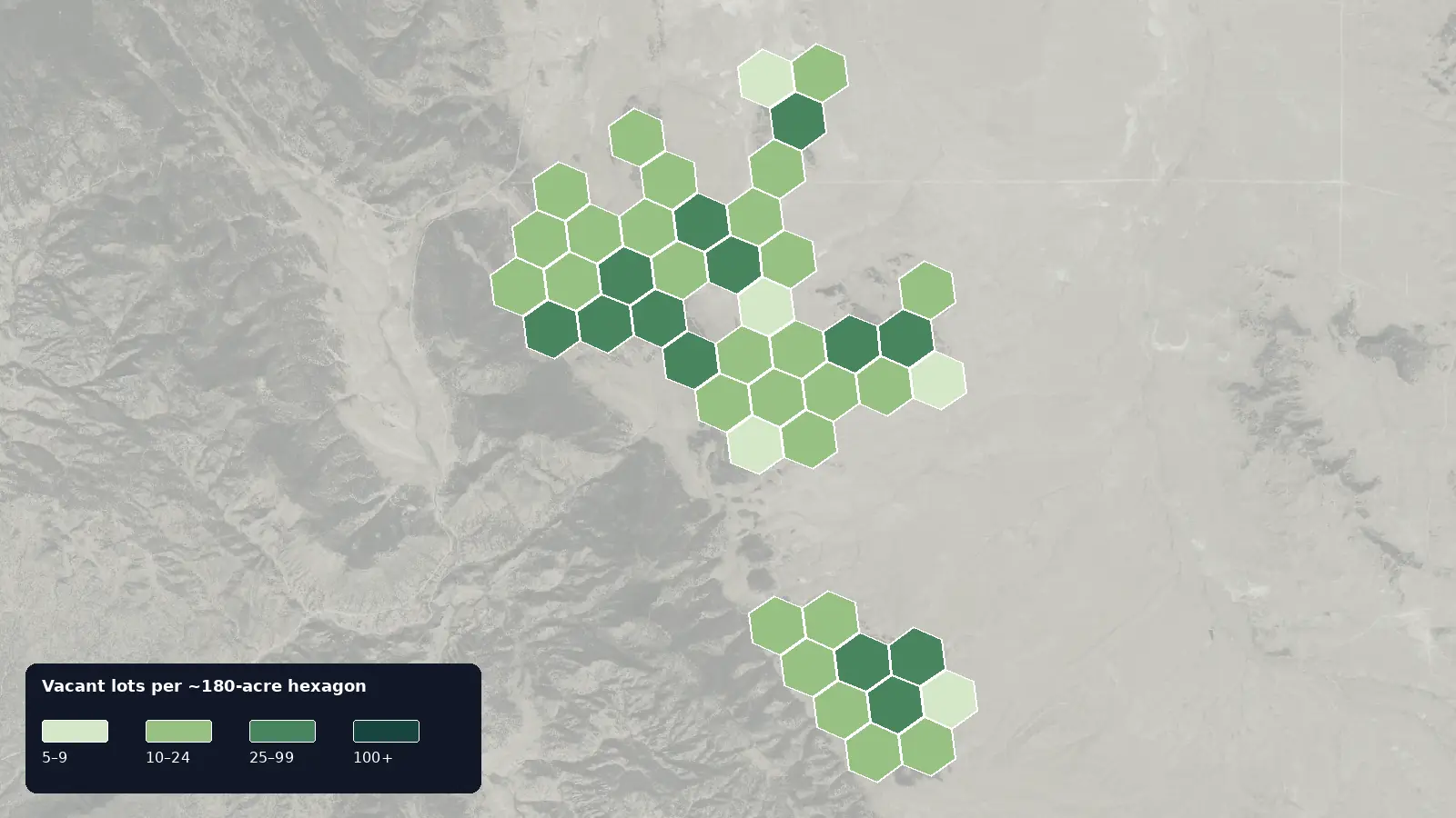
- The 2026 Colorado parcel and assessment data lists 911 vacant residential lots in Western Union Ranch; 63% are mini-estate (2-3 acres)s, and the median lot is 3.00 acre.
- How is a cash offer for land in Western Union Ranch set?
- We review the lot itself, including its size, location, access, available services, title and the time and cost of a direct purchase. You get one written number, not a range.
- How do I know a land buyer in Western Union Ranch is legitimate?
- A real buyer closes through an independent, licensed title company and never asks you to pay anything up front. We never charge sellers a fee, deposit or closing-cost advance, and the title company pays you by check or wire at closing.
Local data
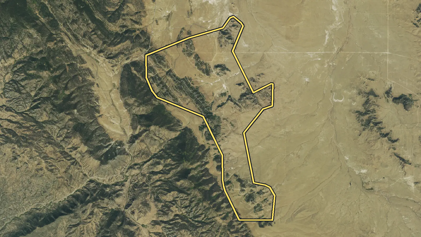
Western Union Ranch land at a glance
Tax-roll figures cover parcels whose subdivision on the Park County extract is Western Union Ranch (any filing) in Park County. Local rules and services are sourced below.
Property addresses here read Hartsel (93%).
| Vacant residential lots | 911 parcels classified vacant residential on the 2026 Colorado parcel and assessment data [1] |
|---|---|
| Most common lot size | Mini-estate (2-3 acres) (70,000–140,000 sq ft): 63% of vacant lots; next, estate parcel (3-5 acres) at 18%. Median lot: 3.00 acre (130,680 sq ft). [1] |
| Owners who live elsewhere | 30% of vacant lots have an owner mailing address outside Colorado (most often TX, FL, CA) [1] |
| Two names for one community | The association's welcome packet says the land became Western Union Ranch around 1968 and that the legal name appears on original subdivision documents; the community uses Ranch of the Rockies. [3] |
| Mountain community scale | The association describes Ranch of the Rockies at about 9,500 feet, with community lots ranging from roughly 2 to 50 acres. [2] |
| Water-plan history | The association's packet says the Western Union Ranch augmentation plan was approved by Water Court in 1975 and later amendments reduced available household-use wells to 1,271. [3] |
| Two fire stations | Hartsel Fire Protection District lists Stations 3 and 5 in Ranch of the Rockies, while its ISO class still depends on the home's road distance to a station. [4],[5] |
| County permits still apply | The association's packet tells owners that Park County permits are required before excavation or construction for a driveway, septic system, dwelling, or accessory structure. [3],[6] |
| Hwy 24 | The association's welcome packet identifies the Highway 24 entrance as the Ranch's main entrance and Trout Creek Pass as its northern entrance. A parcel still needs its own recorded access and road route checked. [3] |
| Antero Reservoir | Park County places Western Union Ranch in T13S, R76W; CPW's map places Antero Reservoir just north in T12S, R76W and marks parking and no-public-access areas. Follow those mapped public points rather than assuming a route from a ranch lot. [9],[10] |
State of Colorado Public parcels were accessed on 2026-10-01 from https://gis.colorado.gov/public/rest/services/Address_and_Parcel
Pricing
What is a lot in Western Union Ranch worth?
What moves the price in Western Union Ranch
Match the legal name to the community records
A title or assessor record may say Western Union Ranch while local material says Ranch of the Rockies. The association's packet explains that Western Union acquired the land around 1968, that the subdivision was developed under that name, and that Ranch of the Rockies became the community identity. This naming link is useful, but it does not make every parcel identical. The legal description, filing, plat, declaration status, easements, and current association records still need review for the specific lot. [3],[2]
Water augmentation is parcel-specific due diligence
The community has a documented water-augmentation history, not an automatic well guarantee for every vacant parcel. The association says the original plan was approved in 1975 and a later amendment reduced available household-use wells to 1,271. Colorado's Division of Water Resources still reviews permit applications, allowed uses, construction records, and basin rules. A buyer should connect the legal lot to the current augmentation records and state permit path before assuming domestic use, livestock use, or limited irrigation rights. [3],[8]
Three-acre patterns still hide site differences
The subdivision match has a median lot size of 3.00 acres, and mini-estate (2-3 acres)s account for 63% of the group. The association describes a broader community range of roughly 2 to 50 acres at about 9,500 feet. Even within that range, slope, tree cover, rock, drainage, driveway length, setbacks, and septic placement can change a buyer's plan. Park County requires a site plan showing the proposed well, wastewater system, watercourses, wetlands, and setbacks, so acreage is only the starting point. [1],[2],[7]
Fire station proximity is measured by road
Hartsel Fire lists two stations in Ranch of the Rockies, but its published ISO classification uses actual road distance. The district reports Class 8B for a home within five road miles of any of its seven stations and Class 10 outside that radius. Buyers may also consider legal access, driveway condition, address visibility, vegetation, and current construction requirements. A station within the named community is helpful context, yet it does not prove the classification or response route for a particular parcel. [4],[5]
Common situations
Selling land in Western Union Ranch in these situations
Your deed says Western Union Ranch, not Ranch of the Rockies
That naming difference is expected in the association's own history. Its packet says Western Union Ranch is the legal name on the original subdivision documents, while the community is known as Ranch of the Rockies. The title company will rely on the recorded legal description and search, not the marketing name. We check title, access, and utilities before making a written offer. [3]
You cannot confirm a well right for the lot
You may still offer the land for sale without obtaining a well permit first. The augmentation plan has a long amendment history, and the state decides permit eligibility and allowed uses. Parcel Buyers buys vacant land with no water or sewer work. Our inspection and records review account for the uncertainty, and a failed inspection contingency costs the seller nothing. [3],[8]
You manage the parcel from outside Colorado
Yes, the closing can be remote. 30% of the matched lots have an owner mailing address outside Colorado, based on the county record. You may use electronic signing or a mail-away closing, and the independent licensed title company can pay by check or wire. Liens or back taxes may be paid from proceeds with the seller's consent. [1]
Step by step
How do I sell my land in Western Union Ranch?
From your first message to money in hand, with nothing left out. Requesting an offer costs nothing and commits you to nothing.
See every detail of the process-
Tell us about your land
Fill out the short form (about 60 seconds) or email us. A land specialist reaches out to confirm the details, usually the same business day.
-
Get your cash offer within 24 hours
We review the property and send a written, no-obligation cash offer within 24 hours. It is a real number, not a range. Take it or leave it, with no pressure either way.
-
Sign electronically
If you accept, everyone signs the purchase agreement electronically. There is nothing to print or mail at this stage.
-
We inspect, the title company verifies
Our team inspects the land and an independent title company runs a title search for liens or taxes owed. If the land does not pass inspection, you are never charged anything.
-
Close and get paid
The title company prepares the closing documents for notarization and issues your funds by standard check, overnight check, or wire transfer. A typical sale closes in 10 days.
Questions
Selling land in Western Union Ranch: common questions
Are Western Union Ranch and Ranch of the Rockies the same place?
They refer to the same broader subdivision community in the association's materials. Its welcome packet says Western Union Ranch is the legal name on original documents, while the current community and association use Ranch of the Rockies.
Does the water augmentation plan guarantee my lot a well?
No. The association documents a 1975 plan and later amendments, but a specific parcel still needs a current state permit review. Colorado's Division of Water Resources determines allowed uses and may apply special-basin rules.
Does the association replace Park County construction permits?
No. The association's packet states that county permits are required before excavation or construction for a driveway, septic system, dwelling, or accessory structure. Recorded declarations or association review can be additional layers, not substitutes for county approval.
Will every parcel have the same fire insurance class?
No. Hartsel Fire lists two community stations, but its ISO rule depends on road distance. The district reports Class 8B within five road miles of any station and Class 10 outside that distance, so the route for the specific lot matters.
Can I sell without improving the road, well, or septic?
Yes. Parcel Buyers buys vacant land with no water, sewer, or road work. We review legal access, the well-permit path, septic requirements, and title before offering. You do not have to complete those improvements first.
Owner resources
Guides for your situation
- Can You Sell Land With a Lien?
Yes. Land with a lien can often be sold, but signing a deed does not by itself erase a valid claim. The lien may need to be paid, released, discharged, or otherwise resolved under the law that applies. With the seller's consent, an approved payoff can come from sale proceeds at closing. If the balance or lien is wrong, dispute it before closing and require proof of the cure.
- Can You Build on a Vacant Lot?
Maybe. A vacant lot is buildable only if the proposed use fits the rules that apply to that parcel and the site can satisfy access, utility, environmental, and permit requirements. Start with the local planning or zoning office, confirm that the parcel is a legal lot, and get a written parcel-specific answer. A zoning label or tax parcel number alone is not approval to build.[1][2]
- How to Sell Land From Another State
You usually do not have to travel to sell land in another state. A title company, escrow company, or closing attorney can coordinate title review, approved signing and notarization, recording, and payment by check or wire. The main limits are state-specific deed rules and title: every owner and signer must have authority. Independently verify the parcel, closing company, and payment instructions before signing.
More places in Park County
Your written offer
Get your cash offer
Four short steps, about 60 seconds. We review your property and send a written, no-obligation cash offer within 24 hours. You can take it or leave it.
What happens after you send this
- A land specialist reaches out, usually the same business day, to confirm the details.
- You get a written cash offer within 24 hours: a real number, not a range.
- You decide. Requesting an offer costs nothing and commits you to nothing.
You will never be asked to pay us anything. No deposit, no processing fee, no closing-cost advance.
Nearby areas we buy
- Hartsel
9,398 vacant lots
- Hartsel Ranch
1,161 vacant lots
- Park County
21,975 vacant lots countywide
How we made this page
Parcel Buyers is a land-buying company based in Florida. We buy vacant land directly from owners and publish these local pages so owners can see what land in their area is doing before they sell, to us or anyone else. We count the tax-roll figures ourselves from state data, take local rules and fees from the official sources listed below, and use AI tools to help research and draft the text. Every number links to its source, and we update the page when the data changes.
Method and sources
Parcel and assessment figures cover parcels whose subdivision on the Park County extract is Western Union Ranch (any filing). Source [1] is our own aggregate count of the State of Colorado Public Parcels county extracts or, for Pueblo, Huerfano and El Paso, the official county source named in the source data. Vacant-lot counts use existing OIT counties retain their documented 0100/0400 or county vacant-class rules. Pueblo uses the county proxy Improvem_1 = 0, LandActual > 0, TaxExempt = no and MobileHome = no; 11 of 120 sampled rows intersected a county building footprint (9.2% error band). Huerfano uses use_code 100/400 with actual_imp = 0. El Paso uses numeric LANDCODE 100 with blank/zero IMPCount (the current export encodes zero as blank) and drops legal descriptions starting TR, TRACT or OUTLOT. These are source-record screens, not physical-vacancy or buildability findings. Lot sizes use existing OIT counties retain the documented acreage, square-foot or geometry method. Pueblo uses county SHAPE.STArea() square feet. Huerfano converts land_size_ according to land_units (SF stays square feet; AC is multiplied by 43,560) and otherwise uses positive master_acr. El Paso converts county Acreage to square feet. All are bucketed with the Parcel Buyers lot sizing chart ([low, high) square feet). Values use county-specific assessor fields: OIT apprValTot for the original counties, Pueblo LandActual, Huerfano total_actu and El Paso MARKETVALUE. These are assessor values, not sale prices, offers or parcel appraisals by Parcel Buyers. Owner locations use owner mailing state of record from each approved source; in_state = Colorado. Mailing state does not prove residence, owner type, motivation or willingness to sell. Owner names were used only in-memory or in a server-side grouped query for the 10% concentration gate and were never stored. Treat medians as a guide to county records, not as an offer or an appraisal. Page updated October 7, 2026.
State of Colorado Public parcels were accessed on 2026-10-01 from https://gis.colorado.gov/public/rest/services/Address_and_Parcel
- [1] Colorado county assessor and GIS sources and State of Colorado OIT (data); Parcel Buyers (analysis), Colorado county assessor and GIS parcel sources (Pueblo, Huerfano and El Paso) and State of Colorado OIT Colorado Public Parcels (accessed 2026-10-03)
- [2] Ranch of the Rockies Association, Welcome to Ranch of the Rockies (accessed 2026-10-07)
- [3] Ranch of the Rockies Association, Ranch of the Rockies Welcome Packet (accessed 2026-10-07)
- [4] Hartsel Fire Protection District, Hartsel Fire Stations and Locations (accessed 2026-10-07)
- [5] Hartsel Fire Protection District, ISO Rating (accessed 2026-10-07)
- [6] Park County, Colorado, Development Guidelines (accessed 2026-10-07)
- [7] Park County, Colorado, Building, Driveway and Septic Permit Application (accessed 2026-10-07)
- [8] Colorado Division of Water Resources, Well Permitting (accessed 2026-10-07)
- [9] Park County, Colorado, Fire and Ambulance Districts Map (accessed 2026-10-07)
- [10] Colorado Parks and Wildlife, Antero State Trust Land Map (accessed 2026-10-07)