Archuleta County, Colorado
Sell your land in Pagosa Trails for cash
Parcel Buyers buys vacant lots for cash in Pagosa Trails, including compact parcels that may have unfinished utility, access or building work. You get a written, no-obligation cash offer within 24 hours, and closings run through an independent title company, typically in about 10 days, with no fees or commissions.
By Parcel Buyers · · Lot figures from the 2026 Colorado parcel and assessment data · How we made this page
Quick answers
- Who buys land for cash in Pagosa Trails?
- Parcel Buyers is a direct land buyer that makes written, no-obligation cash offers on vacant lots and acreage in Pagosa Trails, Archuleta County, usually within 24 hours. Sales close through an independent title company, typically in about 10 days, with no fees or commissions to the seller.
- How many vacant lots are in Pagosa Trails?
- The 2026 Colorado parcel and assessment data lists 160 vacant residential lots in Pagosa Trails; 44% are quarter-acre lots, and the median lot is 0.21 acre.
- How is a cash offer for land in Pagosa Trails set?
- We review the lot itself, including its size, location, access, available services, title and the time and cost of a direct purchase. You get one written number, not a range.
- How do I know a land buyer in Pagosa Trails is legitimate?
- A real buyer closes through an independent, licensed title company and never asks you to pay anything up front. We never charge sellers a fee, deposit or closing-cost advance, and the title company pays you by check or wire at closing.
Local data
Pagosa Trails land at a glance
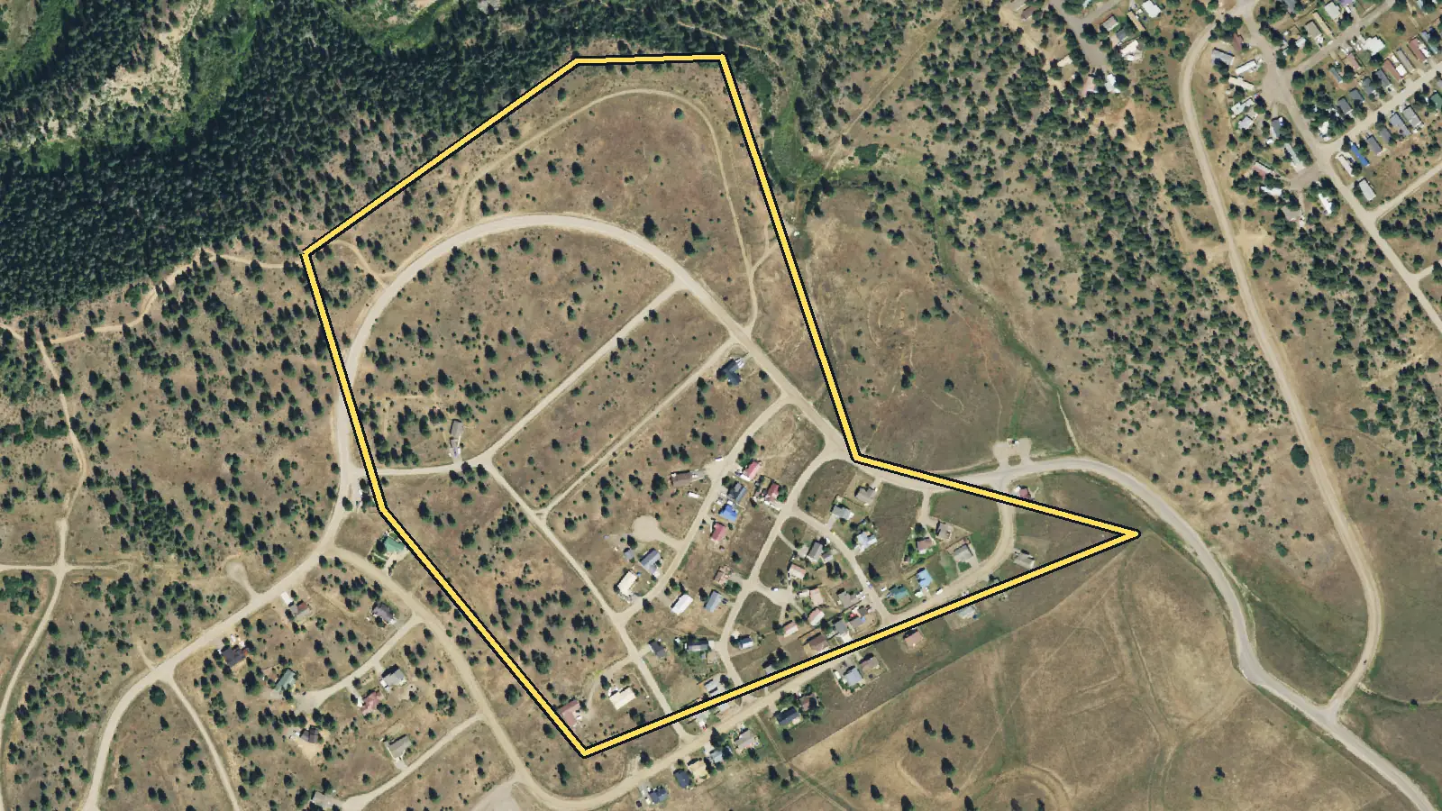
Tax-roll figures cover parcels whose subdivision in the Archuleta County legal description is Pagosa Trails in Archuleta County. Local rules and services are sourced below.
| Vacant residential lots | 160 parcels classified vacant residential on the 2026 Colorado parcel and assessment data [1] |
|---|---|
| Most common lot size | Quarter-acre lot (9,000–13,000 sq ft): 44% of vacant lots; next, standard city lot at 24%. Median lot: 0.21 acre (9,150 sq ft). [1] |
| Typical county assessor value | $19,800 median county assessor value for a vacant lot; the middle half fall between $19,800 and $19,800 [1] |
| Owners who live elsewhere | 48% of vacant lots have an owner mailing address outside Colorado (most often FL, TX, AZ) [1] |
| Exact legal-description group | The page statistics include only parcels whose Archuleta County legal description identifies the Pagosa Trails subdivision. They do not represent a municipal boundary. [1],[2],[6] |
| Recorded plat date | A 2025 County resolution identifies the subdivision plat as filed September 13, 1971, Reception No. 74885, in the Archuleta County Clerk and Recorder's office. [2] |
| Layered declarations | PLPOA's governing-documents page lists Pagosa Vista/Pagosa Trails among areas with individual declarations in addition to the Pagosa Lakes declarations. [3] |
| Compact-lot permit needs | County building applications require a licensed-surveyor site plan, access approval, sanitation proof and applicable association approval. Normal review guidance is at least 15 business days. [7] |
| PAWSD distance rule | PAWSD says property without a water or wastewater main within 100 feet may face a $1,500 nonrefundable plan-review fee plus the full construction cost of an extension. [4] |
| OWTS approval | Where public sewer is unavailable or not feasible, Archuleta County Water Quality reviews OWTS plans and inspections. An approved permit is required before system installation. [8],[9] |
| Chimney Rock National Monument | Archuleta County's map places Chimney Rock southwest of Pagosa Trails. The national monument protects 4,726 acres of San Juan National Forest and includes no private surface land. [10],[11] |
State of Colorado Public parcels were accessed on 2026-10-01 from https://gis.colorado.gov/public/rest/services/Address_and_Parcel
Pricing
What is a lot in Pagosa Trails worth?
What moves the price in Pagosa Trails
Small parcel geometry and lot consolidation
The median parcel in this legal-description group is 0.21 acres, and quarter-acre lots make up 44% of lots coded vacant residential. On a small lot, survey lines, setbacks, easements, driveway room and sanitation needs can overlap. A 2025 County resolution approved the consolidation of two subdivision lots under the county's lot-consolidation rules, showing that a combined-lot path exists when an application meets current requirements. A buyer still must evaluate the individual survey and legal configuration. [1],[2],[7]
Existing utility line, paid tap or required extension
Three different facts can be confused: district eligibility, a line near the lot and a completed connection. PAWSD's 2026 summary says a property without a main within 100 feet can owe a $1,500 nonrefundable plan-review fee and all extension construction costs. For eligible service, separate connection and capital investment charges also apply. A compact lot with a paid tap and a known line is easier to underwrite than one where the future builder must fund an extension or redesign around easements. [4],[5]
Declarations and architectural review
PLPOA identifies Pagosa Vista/Pagosa Trails as an area with an individual declaration as well as the broader Pagosa Lakes declarations. The county residential packet asks for a letter from an architectural control committee, HOA or POA when applicable. Those documents can shape building type, placement and exterior approval. A cash buyer needs the current declaration set, association status and any recorded lien information before treating the land as ready for a standard house plan. [3],[7]
Sanitation space on a compact lot
Public sewer status can be decisive where the parcel is small. County OWTS rules say a new system cannot be permitted when public sewer is available and feasible unless the provider decides otherwise. If an OWTS route is allowed, the county reviews the plan and performs inspections. The same site must also hold the house, access and required setbacks. Utility records and usable area therefore belong in the land inspection; the owner does not have to order a system design before asking for an offer. [9],[8],[7]
Common situations
Selling land in Pagosa Trails in these situations
You own two adjoining subdivision lots
Yes. You can offer adjoining lots together. Archuleta County has a formal lot-consolidation process, and its 2025 resolution for this subdivision shows two lots being combined after the application met the county rules. You do not need to complete a consolidation before requesting an offer. Both lots can be covered by the land inspection before a combined purchase is accepted. [2]
You do not know whether utility fees were paid
Yes. Missing tap paperwork is a diligence issue rather than a bar to sale. PAWSD separates connection charges, capital investment fees, availability charges and line-extension costs. We check utilities, access and title before offering, so unresolved work can be reflected in the written offer. The independent title company handles the transfer once title requirements are satisfied. [4],[5]
Association letters and old documents are incomplete
Yes. An owner does not have to assemble a future building-permit package merely to sell vacant land. PLPOA maintains governing documents and subdivision declarations, while the title company reviews recorded restrictions and liens. The only contingency is our land inspection. If the inspection does not work, the seller pays nothing for that failed contingency. [3],[7]
Step by step
How do I sell my land in Pagosa Trails?
From your first message to money in hand, with nothing left out. Requesting an offer costs nothing and commits you to nothing.
See every detail of the process-
Tell us about your land
Fill out the short form (about 60 seconds) or email us. A land specialist reaches out to confirm the details, usually the same business day.
-
Get your cash offer within 24 hours
We review the property and send a written, no-obligation cash offer within 24 hours. It is a real number, not a range. Take it or leave it, with no pressure either way.
-
Sign electronically
If you accept, everyone signs the purchase agreement electronically. There is nothing to print or mail at this stage.
-
We inspect, the title company verifies
Our team inspects the land and an independent title company runs a title search for liens or taxes owed. If the land does not pass inspection, you are never charged anything.
-
Close and get paid
The title company prepares the closing documents for notarization and issues your funds by standard check, overnight check, or wire transfer. A typical sale closes in 10 days.
Questions
Selling land in Pagosa Trails: common questions
Can two Pagosa Trails lots be combined?
Yes, if the county approves the application under the rules then in effect. A County resolution adopted in January 2025 consolidated two subdivision lots into one legal lot. Future owners must apply rather than assume adjacent parcels are already combined.
What if the utility main is more than 100 feet away?
PAWSD says a main-line extension may be required. Its 2026 summary lists a $1,500 nonrefundable plan-review fee at the start, while the applicant pays construction costs for the extension. The actual path depends on district eligibility, engineering and the specific service requested.
Do I need POA approval before selling the vacant lot?
A future house approval is separate from the land sale. The county packet asks for association approval only when applicable to a building application. PLPOA lists subdivision and master declarations; title and association records must be checked for transfer requirements.
Can a compact lot use an on-site wastewater system?
Possibly, but approval is site-specific. Archuleta County reviews OWTS permits and inspections, while its rules bar a new system where public sewer is available and feasible unless the provider authorizes otherwise. Usable soil area and setbacks also matter to the design.
Will a future county home permit need a survey?
Yes. The county residential packet requires an 11-by-17 proposed site plan prepared by a Colorado-licensed surveyor. It must show details including the legal description, easements, setbacks, structures, driveway grades, well and septic locations, wetlands, slopes and flood-zone information.
Owner resources
Guides for your situation
- Selling Land With Boundary or Survey Problems
Land with a boundary or survey problem can still be offered for sale, but closing may depend on how the buyer, lender, and title insurer handle it. The contract and closing requirements determine whether a survey is needed. A fence does not by itself establish the record boundary. A survey can identify gaps, overlaps, occupation lines, and encroachments; a competing Florida title claim may require a quiet-title action.[1][6][7]
- Can You Build on a Vacant Lot?
Maybe. A vacant lot is buildable only if the proposed use fits the rules that apply to that parcel and the site can satisfy access, utility, environmental, and permit requirements. Start with the local planning or zoning office, confirm that the parcel is a legal lot, and get a written parcel-specific answer. A zoning label or tax parcel number alone is not approval to build.[1][2]
- Cash Buyer vs. Realtor vs. FSBO for Land
No path always nets the most. A land agent can market the parcel broadly, FSBO can avoid hiring a listing agent but shifts the sale work to the owner, and accepting a direct cash offer can avoid public marketing and buyer mortgage approval. Compare written net proceeds, contingencies, closing costs, timing, and your workload—not the headline offer alone. Title problems can delay any route.
More places in Archuleta County
Your written offer
Get your cash offer
Four short steps, about 60 seconds. We review your property and send a written, no-obligation cash offer within 24 hours. You can take it or leave it.
What happens after you send this
- A land specialist reaches out, usually the same business day, to confirm the details.
- You get a written cash offer within 24 hours: a real number, not a range.
- You decide. Requesting an offer costs nothing and commits you to nothing.
You will never be asked to pay us anything. No deposit, no processing fee, no closing-cost advance.
Nearby areas we buy
- Pagosa Springs
1,128 vacant lots · County-recorded median last sale price $63,000
- Pagosa Highlands Estates
218 vacant lots · County-recorded median last sale price $56,800
- Pagosa Meadows
155 vacant lots · County-recorded median last sale price $250,000
- Archuleta County
3,988 vacant lots countywide
How we made this page
Parcel Buyers is a land-buying company based in Florida. We buy vacant land directly from owners and publish these local pages so owners can see what land in their area is doing before they sell, to us or anyone else. We count the tax-roll figures ourselves from state data, take local rules and fees from the official sources listed below, and use AI tools to help research and draft the text. Every number links to its source, and we update the page when the data changes.
Method and sources
Parcel and assessment figures cover parcels whose subdivision in the Archuleta County legal description is Pagosa Trails. Source [1] is our own aggregate count of the State of Colorado Public Parcels county extracts or, for Pueblo, Huerfano and El Paso, the official county source named in the source data. Vacant-lot counts use existing OIT counties retain their documented 0100/0400 or county vacant-class rules. Pueblo uses the county proxy Improvem_1 = 0, LandActual > 0, TaxExempt = no and MobileHome = no; 11 of 120 sampled rows intersected a county building footprint (9.2% error band). Huerfano uses use_code 100/400 with actual_imp = 0. El Paso uses numeric LANDCODE 100 with blank/zero IMPCount (the current export encodes zero as blank) and drops legal descriptions starting TR, TRACT or OUTLOT. These are source-record screens, not physical-vacancy or buildability findings. Lot sizes use existing OIT counties retain the documented acreage, square-foot or geometry method. Pueblo uses county SHAPE.STArea() square feet. Huerfano converts land_size_ according to land_units (SF stays square feet; AC is multiplied by 43,560) and otherwise uses positive master_acr. El Paso converts county Acreage to square feet. All are bucketed with the Parcel Buyers lot sizing chart ([low, high) square feet). Values use county-specific assessor fields: OIT apprValTot for the original counties, Pueblo LandActual, Huerfano total_actu and El Paso MARKETVALUE. These are assessor values, not sale prices, offers or parcel appraisals by Parcel Buyers. Owner locations use owner mailing state of record from each approved source; in_state = Colorado. Mailing state does not prove residence, owner type, motivation or willingness to sell. Owner names were used only in-memory or in a server-side grouped query for the 10% concentration gate and were never stored. Sale figures use existing OIT counties retain their documented calendar-2025 last-sale screen. Pueblo has no sale field. Huerfano has no price field; sale_date supports a 2025 qualifying parcel-row transfer count only, not a price or deed count. El Paso prices require a 2025 last-sale date, $1,000+, and AsrSaleCmnt exactly Vacant Land or Arms-Length Sale; medians publish only at n >= 10. Treat medians as a guide to county records, not as an offer or an appraisal. Page updated October 7, 2026.
State of Colorado Public parcels were accessed on 2026-10-01 from https://gis.colorado.gov/public/rest/services/Address_and_Parcel
- [1] Colorado county assessor and GIS sources and State of Colorado OIT (data); Parcel Buyers (analysis), Colorado county assessor and GIS parcel sources (Pueblo, Huerfano and El Paso) and State of Colorado OIT Colorado Public Parcels (accessed 2026-10-03)
- [2] Archuleta County Board of County Commissioners, Resolution 2025-9, Pagosa Trails Lot Consolidation (accessed 2026-10-07)
- [3] Pagosa Lakes Property Owners Association, Governing Documents (accessed 2026-10-07)
- [4] Pagosa Area Water and Sanitation District, 2026 Summary of Charges (accessed 2026-10-07)
- [5] Pagosa Area Water and Sanitation District, New Connection Information and 2026 Fees (accessed 2026-10-07)
- [6] Archuleta County, Planning Department (accessed 2026-10-07)
- [7] Archuleta County Building Division, Residential Information Packet (accessed 2026-10-07)
- [8] Archuleta County Finance Portal, Development Services - Water Quality (accessed 2026-10-07)
- [9] Archuleta County Public Health, Archuleta County On-site Wastewater Treatment System Regulations 2024 (accessed 2026-10-07)
- [10] Archuleta County, Archuleta County General Reference Map (accessed 2026-10-07)
- [11] U.S. Forest Service, Chimney Rock National Monument Questions and Answers (accessed 2026-10-07)